|
Flinders Ranges National Parks & Wildlife
South Australia
Flinders
Range National Park
92,746
hectares
Telephone (08) 8648
4244
The Flinders Ranges
National Park occupies
much of the central
Flinders Ranges. It
is an extremely popular
park, and takes in rugged
mountain scenery, peaceful
timbered gorges, with
plenty of wildlife,
vegetation and history.
Picture-perfect Edeowie
and Brachina Gorges,
Aroona and Bunyeroo
valleys and stunning
Wilpena Pound are the
park's major attractions.
Wildlife can be seen
everywhere in the
park - wedge-tailed
eagles, soaring above
their rocky eyries
rare yellow-footed
rock wallabies making
their way along ledges,
western grey kangaroos
grazing undisturbed
and flocks of colourful
birds swooping here
and there.
With the right conditions,
wildflowers burst
onto the landscape
around spring, transforming
an already beautiful
scene into a brilliant
wilderness. Occasionally,
such as at Aroona
and in Wilpena Pound,
you come across the
ruins of a farmhouse
or shed, silent reminders
that this is a harsh,
unforgiving land.
The park is a popular
destination, ideal
for bushwalking, photography,
birdwatching, camping
and sightseeing.
Gammon
Ranges National Park
128,228
hectares
Telephone (08) 8648
4829
In the far north of
the Flinders Ranges
and west of Arkaroola,
the Gammon Ranges National
Park incorporates a
rugged wilderness of
mountains, gorges and
inaccessible country.
While there is plenty
of wildlife in the park,
many species take advantage
of the difficult and
inaccessible terrain;
only experienced hikers
should attempt to venture
off the beaten track.
A major highlight of
the Gammon Ranges National
Park is Italowie Gorge,
where near-perpendicular
cliff faces of red quartzite
compete with the red
river gums growing along
the bed of the creek.
Up higher, native pines
fight for space in cracks
in the rock and obtain
their sustenance from
the water that collects.
Camping is allowed
in the park, but a
permit must first
be sought from the
ranger headquarters
at Balcanoona.
Conventional cars
can be taken into
the general area of
the park; however,
a four wheel drive
is recommended if
you want to leave
the main road.
Mount
Remarkable National
Park
15,632
hectares
Telephone (08) 8634
7068
This park in the southern
Flinders Ranges lies
between the shores of
Spencer Gulf and the
mountainous regions
surrounding Wilmington
to the north and Melrose
to the south. It incorporates
a variety of topography,
from the temperate lowlands
along the gulf through
the higher wheat country
inland to the ranges
themselves. A wide range
of animals, birds and
plants provides a good
contrast, especially
when coupled with the
park's marvellous scenery.
One of the features
is Mount Remarkable,
named by explorer
Edward John Eyre for
its sheer precipitous
drop. The small town
of Melrose sits under
its protective wing.
There are some excellent
walking trails, some
suited to fit bushwalkers,
others to more sedate
walkers wishing to
explore the park.
Mount Remarkable has
three main points
of access - the him-off
to Mambray Creek,
forty five kilometres
north of Port Pirie
on Highway One; Alligator
Gorge can be reached
with a pretty drive
commencing one kilometre
south of Wilmington;
and the Mount Remarkable
section, directly
behind Melrose, twenty
four kilometres south
of Wilmington.
Telephone (08) 8216
0000
Bushwalking in Flinders Ranges
The
Flinders are a bushwalker's
dream. Intrepid and
experienced walkers,
family groups, day trippers,
dawdlers and speedsters
have a wide choice of
walking trails. The
best-known is the Heysen
Trail, that long distance
footpath of around 1,500
kilometres which begins
at Cape Jervis in the
south and ends its run
in the Central Flinders
Ranges.
It scales Mount Remarkable
and Mount Brown in
the southern ranges,
then continues on
its way north, past
weathered rocks and
steep ridges into
the very centre of
the ranges at Wilpena
Pound. Here the trail
passes into the Pound,
past St. Marys Peak
and on to the deep
purpled sides of Aroona
Valley.
Finally it reaches
for the Central Flinders
area at Parachilna
Gorge, its terminal.
The Heysen Trail is
closed between December
and April; in some
areas this may vary
according to the bushfire
risk.
There are many other
walking trails all
over the ranges, varying
in difficulty and
duration. Most are
well signposted. It
should be remembered
that much of the land
in the Flinders Ranges
is privately- owned
and that therefore
permission should
be sought from the
owners before beginning.
The best time to go
bushwalking in the
Flinders Ranges is
between May and October,
when temperatures
are mild.
Maps of the Heysen
Trail can be purchased
in sections from the
State Information
Centre, 25 Grenfell
Street, Adelaide.
Maps of other walking
trails throughout
the Flinders Ranges
can be obtained from
National Parks and
Wildlife Ranger Headquarters
or from tourist information
offices.
For more travel information on Flinders Ranges & Top Destination Flinders Ranges
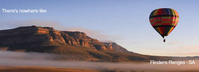
Photo courtesy SATC
|
|
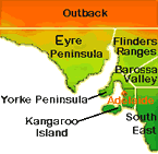
South Australian Region
Map |
|
Yorke Peninsula Information |
|
|