|
YANAKIE
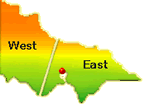
Yanakie
is
located
on
the
Peninsula
of
Wilsons
Promontory,
South
Gippsland,
and
the
Southernmost
Landmass
on
the
Australian
Mainland.
Yanakie
is
approximately
a
two
hour
drive
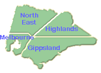
from
Melbourne
via
the
South
Gippsland
Highway,
(just
follow
the
Wilsons
Promontory
signs
at
all
times),
and
the
last
(and
only)
town
on
the
peninsula
before
the
'Prom'
National
Park
gate.
The
village
is
situated
in
a
rural
location,
overlooking
rolling
farmland,
and
is
only
a
few
minutes
drive
to
beaches
(Corner
Inlet
&
Shallow
Inlet)
on
either
side
of
the
Peninsula.
This
is
a
great
destination
for
those
interested
in
discovering
the
majestic
beauty
of
the
Southern
Coastlines,
Inlets
and
bays;
access
to
the
giant
timbers,
the
ferny
valleys
and
water
falls
of
the
Strzelecki
Ranges.
-
Village
Services
-
The
Yanakie
Licensed
General
Store,
fuel
outlet
and
Yanakie
House
&
Gallery
Caf�.
Local
attractions
&
services
-
Milparinkis
Yabbie
farm
and
Tingara
View
Tea
Room
-
B&B
and
Self
Contained
accommodation
providers.
- Two
caravan
parks
on
either
side
of
the
peninsula
-
Boat
launching
facilities
�
Population
-
in
village
12
people
(increasing
in
season)
and
in
the
whole
peninsula
region
-
261
people
(varies
seasonally)
-
On
the
Meeniyan
-
Promontory
Road
in
South
Gippsland,
185
Kms
from
the
GPO
in
Melbourne.
�
8
Kms
from
the
National
Park
gate,
travelling
time
approx
5
mins,
and
30
minutes
to
Tidal
River.
- The
main
town
is
Foster,
28
Kms
to
the
north,
a
20
minutes
drive
-
Surrounded
on
two
sides
by
Inlets
(Corner
&
Shallow
Inlets),
5
minutes
drive
either
way.
-
Local
tennis
courts
&
children's
playground.
-
Fishing,
boating,
swimming,
windsurfing
and
bushwalking.
- A
great
base
for
the
artist,
photographer,
fisherman,
Prom
enthusiast,
or
weary
traveller.
 HISTORY
'YANAKIE
(yan-a-key)
-
a
Koori
name
from
the
Gunai
(Kurnai)
language
interpreted
generally
as
'between
waters'
-
More
than
12,000
years
ago,
when
the
sea
level
was
six
metres
higher
than
at
present,
'The
Prom'
was
a
group
of
islands
with
only
the
mountain
tips
showing
above
water
level.
When
the
sea
level
dropped,
(to
form
the
land
bridge
to
Tasmania),
a
series
of
sand
dunes
formed
over
a
basalt
base
creating
the
Yanakie
Peninsula.
This
constructed
a
link
between
the
previous
islands
and
the
mainland,
so
that
when
the
sea
level
rose
again,
it
thus
formed
what
is
now
the
present
day
Wilsons
Promontory. HISTORY
'YANAKIE
(yan-a-key)
-
a
Koori
name
from
the
Gunai
(Kurnai)
language
interpreted
generally
as
'between
waters'
-
More
than
12,000
years
ago,
when
the
sea
level
was
six
metres
higher
than
at
present,
'The
Prom'
was
a
group
of
islands
with
only
the
mountain
tips
showing
above
water
level.
When
the
sea
level
dropped,
(to
form
the
land
bridge
to
Tasmania),
a
series
of
sand
dunes
formed
over
a
basalt
base
creating
the
Yanakie
Peninsula.
This
constructed
a
link
between
the
previous
islands
and
the
mainland,
so
that
when
the
sea
level
rose
again,
it
thus
formed
what
is
now
the
present
day
Wilsons
Promontory.
Wilsons
Promontory
was
first
travelled
by
the
Koories
(as
south-eastern
Australian
Aboriginals
prefer
to
call
themselves).
These
people
were
the
Gunai
(Kurnai)
community
with
the
Brataualung
clan
occupying
the
surrounding
areas
of
South
Gippsland.
To
the
Koories,
Wilsons
Promontory
is
known
as
'Wamoon',
(also
known
as
Yirik
or
Woomom),
watched
over
by
their
spirit
ancestor,
'Loo-errn'.
These
people
had
been
spending
at
least
part
of
their
year
on
the
Yanakie
Peninsula
for
approximately
6500
years
prior
to
the
arrival
of
George
Bass
in
1798.
Originally,
in
the
shire
of
South
Gippsland,
Yanakie
was
one
of
the
parishes
in
the
County
of
Buln-Buln
on
Wilsons
Promontory,
along
with
the
other
parishes
-
Beek-Beek,
Warreen,
Kulk
and
Tallang.
The
northern
section
of
Yanakie
was
probably
exempted
from
the
National
Park
(declared
in
1905
-
internal
section
only,
1908
-
the
coastline,
and
in
the
1950's
-
the
Yanakie
southern
section)
on
the
grounds
of
revenue.
A
lease
had
been
granted
in
1852
for
the
Yanakie
Station
or
Run
(a
profitable
business),
which
originally
grazed
cattle
through
to
Darby
River.
Yanakie
has
only
been
developed
into
dairying
country
since
the
1950's...
Prior
to
development,
Yanakie
(also
called
the
Yanakie
Common)
was
open
heathy
plains
with
the
'Red
Swamp',
'White
Swamp
and
'Black
Swamps',
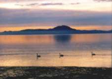
supporting
vast
birdlife
including
the
black
swans
and
brolgas.
It
is
interesting
to
note
that
very
few
of
these
original
Koori
(aboriginal)
parish
names
exist
on
the
National
Park
today�
 Since
the
time
of
European
discovery,
exploitation
has
vastly
changed
some
of
the
land
and
the
surrounding
sea.
One
record
of
the
extent
of
this
is
the
impact
on
seal
numbers
-
in
1804
the
American
ship
'Union'
obtained
600,000
seal
skins
-
today
we
have
nowhere
near
this
number
in
the
whole
of
the
southern
Australian
waters.
When
this
industry
collapsed
they
turned
their
attention
towards
harvesting
the
oil
of
muttonbirds
(short-tailed
Shearwaters),
and
whaling.
(Local
timber
was
used
for
fuel
to
boil
down
the
blubber)
A
timber
mill
was
set
up
in
Sealers
Cove
in
1849,
but
lasted
only
until
1858,
when
presumably
all
the
accessible
tall
timber
had
been
removed.
(A
revival
of
the
timber
milling
occurred
again
between
1903
to
1906,
with
a
small
town
comprising
16
buildings,
a
boarding
house
and
a
community
hall
existed).
Pastoral
leases
were
granted
from
approximately
1851
onward
in
Sealers
Cove
and
the
Yanakie
region,
with
varied
successes. Since
the
time
of
European
discovery,
exploitation
has
vastly
changed
some
of
the
land
and
the
surrounding
sea.
One
record
of
the
extent
of
this
is
the
impact
on
seal
numbers
-
in
1804
the
American
ship
'Union'
obtained
600,000
seal
skins
-
today
we
have
nowhere
near
this
number
in
the
whole
of
the
southern
Australian
waters.
When
this
industry
collapsed
they
turned
their
attention
towards
harvesting
the
oil
of
muttonbirds
(short-tailed
Shearwaters),
and
whaling.
(Local
timber
was
used
for
fuel
to
boil
down
the
blubber)
A
timber
mill
was
set
up
in
Sealers
Cove
in
1849,
but
lasted
only
until
1858,
when
presumably
all
the
accessible
tall
timber
had
been
removed.
(A
revival
of
the
timber
milling
occurred
again
between
1903
to
1906,
with
a
small
town
comprising
16
buildings,
a
boarding
house
and
a
community
hall
existed).
Pastoral
leases
were
granted
from
approximately
1851
onward
in
Sealers
Cove
and
the
Yanakie
region,
with
varied
successes.
LOCAL
BEACHES
AND
WALKS
AROUND
YANAKIE
SHALLOW
INLET
Hourigan
Camp
Lane
Walk
-
This
section
of
'The
Prom'
offers
visitors
long
sandy
beaches
after
a
pleasant
stroll
through
a
sheltered
gully.
By
walking
quietly
along
the
track,
you
may
see
and
hear
the
various
birds
and
animals
in
their
natural
habitat.
The
beach
offers
sandy
tidal
flats,
where
at
low
tide
the
channel
is
clearly
visible
and
on
high
tide
a
vast
sheet
of
water
consumes
the
Inlet.
The
area
forms
part
of
the
Shallow
Inlet
Marine
and
Coastal
Park
and
is
popular
for
fishing
and
windsurfing.
From
Millar
Road
(see
map)
turn
into
-
'Hourigan
Camp
Lane',
a
short
unmade
road,
and
drive
to
the
carpark.
Once
you
pass
through
the
small
gate,
you
are
in
Wilsons
Promontory
National
Park.
Follow
the
track
along
the
boardwalk
to
the
beach.
Distance:
400metres/10
-
15mins
one
way
-
an
easy
walk.
Lester
Road
-
at
the
end
of
this
road
was
the
site
of
the
original
guest
house
for
those
wishing
to
travel
further
into
the
Promontory.
From
this
location,
people
would
wait
until
low
tide,
then
set
off
driving
around
the
beach
of
Shallow
Inlet,
along
Cotters
Beach,
finally
making
their
way
down
to
the
'Darby
River
Chalet'
(now
demolished).
Here
you
will
find
a
lovely
beach
side
picnic
area
near
the
caravan
park.
Adams
Road
-
after
a
little
climb
down
to
the
beach,
you
will
find
yourself
at
the
lower
reaches
of
the
Shallow
Inlet
channel.
This
vast
area
is
the
nursery
and
breeding
ground
of
several
fish
species.
 CORNER
INLET
Duck
Point
Walk
-
Commencing
on
Foley
Road,
this
trail
leads
through
thickets
of
Coastal
Tea-tree
to
the
sheltered
waters
of
Corner
Inlet.
Scenic
views
across
the
Inlet
to
the
peaks
of
Wilsons
Promontory
are
the
feature
of
this
walk.
Distance
800
metres/30min
return
Shellcot
Road
-
enter
reserve
area
marked
'Red
Bluff'
and
follow
track
to
beach.
It
is
very
pleasant
to
walk
in
either
direction,
but
to
the
right
you
will
see
the
'Red
Bluff'
jutting
out.
('Red
Bluff'
is
formed
out
of
a
very
reddish
clay)
This
is
a
very
tidal
area.
Bluff
Road
-
Follow
a
very
bushy
track
down
to
the
boat
sheds.
This
is
a
mangrove
area
and
can
be
quite
squelchy
under
foot.
To
the
left,
towards
'Red
Bluff',
the
very
rare
'Yanakie
Berry
'
(bright
red
berries
with
very
prickly
leaves)
can
be
seen
in
fruit
in
the
late
Autumn
and
early
Winter.
From
this
location
enjoy
the
wonderful
views
over
the
Inlet
Be
aware
that
this
is
a
tidal
area,
and
even
at
low
tide
the
shoreline
can
be
very
boggy.
Yanakie
Landing
Walk
-
Starting
at
Foley
Road
the
track
wends
its
way
down
to
the
rocky
beach
area,
then
back
up
through
the
Old
Quarry.
Distance
approximately
a
1.3km
circuit
with
some
steep
sections.
The
lookout
has
good
views
of
Corner
Inlet
and
over
Mt.Singapore,
Mt.Vereker,
Mt.Margaret,
Mt.Hunter,
Mt.Roundback
and
Chinamans
Knob.
Charles
Hall
Road
-
an
excellent
location
for
observing
the
pristine
environment
and
habitat
of
many
species
of
wading
birds.
This
is
a
very
fragile
and
significant
location
with
its
marshes
and
small
creeks,
so
tread
gently. CORNER
INLET
Duck
Point
Walk
-
Commencing
on
Foley
Road,
this
trail
leads
through
thickets
of
Coastal
Tea-tree
to
the
sheltered
waters
of
Corner
Inlet.
Scenic
views
across
the
Inlet
to
the
peaks
of
Wilsons
Promontory
are
the
feature
of
this
walk.
Distance
800
metres/30min
return
Shellcot
Road
-
enter
reserve
area
marked
'Red
Bluff'
and
follow
track
to
beach.
It
is
very
pleasant
to
walk
in
either
direction,
but
to
the
right
you
will
see
the
'Red
Bluff'
jutting
out.
('Red
Bluff'
is
formed
out
of
a
very
reddish
clay)
This
is
a
very
tidal
area.
Bluff
Road
-
Follow
a
very
bushy
track
down
to
the
boat
sheds.
This
is
a
mangrove
area
and
can
be
quite
squelchy
under
foot.
To
the
left,
towards
'Red
Bluff',
the
very
rare
'Yanakie
Berry
'
(bright
red
berries
with
very
prickly
leaves)
can
be
seen
in
fruit
in
the
late
Autumn
and
early
Winter.
From
this
location
enjoy
the
wonderful
views
over
the
Inlet
Be
aware
that
this
is
a
tidal
area,
and
even
at
low
tide
the
shoreline
can
be
very
boggy.
Yanakie
Landing
Walk
-
Starting
at
Foley
Road
the
track
wends
its
way
down
to
the
rocky
beach
area,
then
back
up
through
the
Old
Quarry.
Distance
approximately
a
1.3km
circuit
with
some
steep
sections.
The
lookout
has
good
views
of
Corner
Inlet
and
over
Mt.Singapore,
Mt.Vereker,
Mt.Margaret,
Mt.Hunter,
Mt.Roundback
and
Chinamans
Knob.
Charles
Hall
Road
-
an
excellent
location
for
observing
the
pristine
environment
and
habitat
of
many
species
of
wading
birds.
This
is
a
very
fragile
and
significant
location
with
its
marshes
and
small
creeks,
so
tread
gently.
BASS
At
the
town
of
Bass
on
the
Bass
Highway,
you'll
discover
the
extraordinary
Wildlife
Wonderland.
This
has
four
different
areas
depicting
Australian
wildlife
-
the
giant
worm
attraction,
wombat
world,
kangaroo
enclosure
and
a
farm
yard
featuring
cows,
sheep,
goats
and
a
host
of
other
animals.
Wildlife
Wonderland
allows
visitors
to
have
hands-on
contact
with
some
of
Australia's
most
treasured
animals.
WONTHAGGI
A
90-minute
journey
down
the
South
Gippsland
and
Bass
Highways
brings
you
to
the
former
coal
mining
town
of
Wonthaggi.
The
mines
operated
here
from
1909
till
1968
and,
if
it
were
not
for
coal,
the
town
would
not
have
existed.
The
only
mine
now
in
operation
is
for
tourists.
Known
as
the
State
Coal
Mine
it
was
reopened
in
1982
for
the
making
of
the
film,
"Strikebound".
Former
miners
take
regular
tours
underground
and
show
the
difficult
conditions
in
which
they
once
worked.
INVERLOCH
Inverloch
was
one
of
the
state's
first
seaports
and
much
of
the
first
coal
mined
in
Wonthaggi
was
shipped
to
Melbourne
from
here.
The
township
is
found
at
the
mouth
of
Anderson's
Inlet
and
it
is
best
known
for
its
beaches.
The
coastal
drive
between
Cape
Paterson
and
Inverloch
is
a
must.
It
tracks
along
the
narrow
Bunurong
Cliff
Coastal
Park.
Look
out
for
Eagles
Nest
-
a
peculiar
rock
formation
which
has
long
been
a
prominent
landmark.
KORUMBURRA
Korumburra
is
a
similar
distance
from
Melbourne
and
was
likewise
established
because
of
coal.
Black
coal
was
first
uncovered
here
in
1872
and
by
1889
the
Coal
Creek
Mine
was
producing
the
first
commercially-viable
coal
in
the
state.
Today,
on
the
original
site
of
this
mine,
is
the
Coal
Creek
Historical
Village,
which
features
a
recreation
of
a
coal
mining
town
of
the
1890s.
Coal
Creek
has
established
itself
as
one
of
Gippsland's
major
tourism
destinations
and
is
conveniently
located
on
the
South
Gippsland
Highway.
LEONGATHA
A
10-minute
drive
from
Korumburra
is
the
thriving
farming
town
of
Leongatha,
home
of
the
biggest
dairy
factory
in
the
southern
hemisphere.
Leongatha
was
once
the
home
of
a
labour
colony,
a
settlement
of
unemployed
men
who
cleared
and
farmed
the
area
after
the
completion
of
the
South
Gippsland
railway
in
the
1890s.
FOSTER
Further
down
the
South
Gippsland
Highway
is
the
pretty
former
gold
mining
town
of
Foster.
On
the
way
in
you
will
be
rewarded
with
great
views
of
Wilsons
Promontory
and
Corner
Inlet.
Gold
was
discovered
at
Foster
in
1870
by
a
group
of
timber
cutters.
While
the
finds
were
never
as
rich
as
those
elsewhere
in
Victoria,
goldmining
continued
through
till
the
1930s.
YARRAM
Rejoining
the
South
Gippsland
Highway
and
travelling
east
you
will
happen
upon
the
town
of
Yarram,
formerly
the
site
of
low-lying
swamplands.
John
Carpenter,
an
early
pioneer,
established
a
flour
mill
and
a
saw
mill
in
the
area
in
1857.
PORT
ALBERT
Nearby
is
the
historic
Port
Albert,
discovered
in
1841
by
Angus
McMillan.
It
is
Victoria's
oldest
seaport
and
the
first
settlement
in
Gippsland.
Its
size
belies
the
major
role
it
played
in
the
opening
up
of
the
whole
region.
McMillan
happened
upon
Port
Albert
during
his
search
for
a
southern
port
through
which
to
ship
livestock
between
New
South
Wales
and
Van
Diemen's
Land.
Throughout
the
1840s
more
settlers
arrived
,
gradually
shipping,
banking,
stock
and
other
businesses
were
established.
When
gold
was
discovered
at
Walhalla
and
Omeo,
Port
Albert
became
a
shipping
point
for
something
other
than
cattle.
Its
relevance
as
a
transport
hub
began
to
decline
following
the
establishment
of
the
South
Gippsland
rail
line
in
the
1890s.
A
walk
through
Port
Albert
will
reveal
some
12
historic
buildings
all
with
plaques
affixed.
Today
the
town
is
best
known
for
fishing.
It
provides
access
not
only
to
Bass
Strait
but
to
220
square
kilometres
of
sheltered
estuaries.
Catches
include
flathead,
snapper,
king
george
whiting,
bream,
salmon,
perch
and
mulloway.
LATROBE
VALLEY
Supplying
about
85
per
cent
of
Victoria's
power,
the
Latrobe
Valley
has
long
been
regarded
as
the
state's
"engine
room"
and
contains
three
major
cities
-
Morwell,
Moe
and
Traralgon.
Begining
at
the
town
of
Yarragon,
the
Princes
Highway
plots
the
extent
of
the
Latrobe
Valley
to
its
end
just
east
of
Traralgon.
"The
Valley",
as
it's
called
by
its
residents,
is
home
to
the
State
Electricity
Commission's
giant
open
cut
coal
mine
and
its
extensive
power
generation
plants.
Regular
free
tours
are
conducted
of
the
Morwell
Open
Cut
and
Hazlewood
Power
Station.
This
area
is
sports
mad
as
two
top
class
racecourses
(Moe
and
Traralgon)
and
four
I8-hole
golf
courses
help
testify.
The
Latrobe
Valley
boasts
about
40
a
la
carte
restaurants,
more
than
30
hotels/motels,
extensive
convention
facilities
and
a
good
range
of
caravan
and
camping
grounds.
The
Valley
puts
the
visitor
within
striking
distance
of
some
magnificent
country
such
as
that
found
at
the
Tarra-Bulga,
Baw
Baw,
and
Morwell
National
Parks,
and
at
the
Mount
Worth,
Strezlecki,
Moondara,
Tyers
and
Holey
Plains
State
Parks.
It
is
also
only
a
short
drive
from
the
extraordinary
former
goldmining
town
of
Walhalla.
Just
45
minutes
drive
north
of
Moe
and
found
within
the
Baw
Baw
National
Park
are
the
excellent
cross-country
ski
resorts
of
Baw
Baw
and
Mt
St
Gwinear.
And,
at
Moe,
is
the
Latrobe
Valley's
pride
and
joy
-
Old
Gippstown.
Found
right
on
the
Princes
Highway
this
recreated
township
of
more
than
30
buildings
is
situated
on
3.5
hectares
of
parkland.
It
has
recaptured
the
life
of
early
Gippsland
through
the
eyes
of
the
primary
producer,
the
gold
prospector,
the
retailer
and
the
early
industrialist.
At
Morwell
is
the
Latrobe
Regional
Gallery
which
has
provided
great
support
to
talented
local
artists
through
both
its
acquisitions
and
exhibitions.
WALHALLA
Not
far
north
of
the
Latrobe
Valley
and
nestled
in
the
foothills
of
the
Great
Dividing
Range,
the
Mountain
Rivers
District
provides
a
beautiful
combination
of
history
and
nature.
Here
you
will
find
the
magnificent
former
goldmining
town
of
Walhalla.
It's
almost
as
if
it
has
been
snap
frozen
in
time.
Not
many
people
live
at
Walhalla
but
many
of
its
original
buildings
remain.
These
include
the
fire
station,
museum,
post
office,
Windsor
House,
Mechanics
Institute,
bank
vault
Freemason's
Lodge,
St
John's
Church
of
England
and,
possibly
the
most
photographed
thing
in
Walhalla,
the
grand
old
band
rotunda.
During
the
1880s
Walhalla
was
one
of
the
state's
richest
goldfields.
The
Long
Tunnel
Extended
Mine,
which
operated
from
1871
until
1911,
yielded
8
15,568
ounces
of
gold
and
paid
dividends
of
$2.5
million.
The
hilly
terrain
meant
local
sports
fans
had
to
virtually
cut
the
top
off
a
mountain
in
order
to
establish
a
sports
field
for
football
and
cricket.
The
climb
to
the
top
was
so
arduous
that
local
sportsmen
would
ascend
the
day
before
and
camp
overnight.
ERICA
Not
far
from
Walhalla
is
Erica,
an
historic
timber
town,
where
you
will
see
old
wooden
timber
trestle
bridges,
tram
lines
and
mill
sites.
The
local
hotel
has
an
extensive
display
of
artefacts
while
the
railway
museum
traces
the
history
of
the
Moe
to
Walhalla
line
which
closed
in
1954.
Efforts
are
underway
to
restore
part
of
the
line
for
tourists.
RAWSON
The
township
of
Rawson
was
established
for
workers
constructing
the
giant
Thomson
Dam
which
was
completed
in
1983.
This
dam
supplies
water
to
Melbourne
and
is
an
ideal
place
for
picnics.
The
dam
is
fed
by
the
magnificent
Thomson
River
which
has
established
itself
as
an
excellent
venue
for
whitewater
rafting,
canoeing
and
trout
fishing.
SALE
Sale
is
the
biggest
centre
in
the
area
and
it
is
here
that
you
can
view
the
acclaimed
textile
art
of
the
famous
wildlife
artist
Annemieke
Mein.
A
key
source
of
her
inspiration
is
the
wetlands
of
the
Sale
Common.
For
thousands
of
years
this
labyrinth
of
marshes,
rivers
and
lakes
has
provided
a
haven
for
a
vast
range
of
wildlife.
Sale
is
just
a
20
minute
drive
from
the
famous
90-Mile
Beach,
the
slender
strip
of
coast
which
helps
separate
the
remarkable
Gippsland
Lakes
from
the
ocean.
These
are
comprised
of
three
lakes
-
King,
Victoria
and
Wellington.
These
lakes
are
fed
by
four
navigable
rivers
-
Latrobe,
Mitchell,
Nicholson
and
Tambo.
The
Lakes
incorporate
picturesque
resorts
such
as
Paynesville,
Metung,
Loch
Sport,
Rotamah
Island,
Golden
Beach
and
Seaspray.
Sufficiently
protected
from
the
ocean
winds,
and
without
any
rocks
to
contend
with,
the
Gippsland
Lakes
provide
an
ideal
boating
venue
for
cruisers,
yachts
and
small
craft.
To
a
large
degree
the
area
is
very
much
as
it
was
when
explorer
Angus
McMillan
visited
here
in
the
1840s
and
this
is
mainly
due
to
the
establishment
of
national
parks
covering
almost
20,000
hectares.
MAFFRA
Just
to
the
north
west
of
Sale
is
the
charming
town
of
Maffra
where
the
annual
Gippsland
Harvest
Festival
is
staged
at
the
Powerscourt
Country
House.
This
celebrates
the
produce
provided
by
the
rich
fertile
flood
plains.
Noted
restaurants,
vignerons
and
artists
are
represented
on
one
of
the
most
important
days
on
Central
Gippsland's
calender.
BAIRNSDALE
Bairnsdale
is
a
neat
and
charming
town
found
on
the
banks
of
the
Mitchell
River,
between
Sale
and
Lakes
Entrance
on
the
Princes
Highway.
Both
Sale
and
Bairnsdale
put
the
visitor
in
easy
rich
of
the
high
country
to
the
north.
Most
notable
this
means
the
Alpine
National
Park,
the
Avon
Wilderness
Area
and
the
Mitchell
River
National
Park.
An
ideal
destination
is
the
Den
of
Nargun,
a
ferny
grotto
in
the
Mitchell
River
National
Park
which
is
popular
for
picnics
and
bushwalking.
|