Holiday Destinations Outback Western Australia WA
Pingelly
The
name
is
actually
a
corruption
of
"Pingeculling",
which is the
Aboriginal
word
for
the
area.
Today
the
area
offers
rare
insight
into
Western
Australia's
rich
colonial
heritage.
Narrogin
The
township
of
Narrogin,
in
the
heart
of
Western
Australia's
richest
farming
land,
is
known
for
its
unique
townscape
design
and
gardens.
Wagin
The
town
is
the
centre
of
a
thriving
Merino
Stud
industry
and
proud
home
to
the
"Wagin
Woolorama",
the
states
largest
rural
show.
Dumbleyung
Lake
Dumbleyung
is
one
of
the
largest
semi-permanent
stretches
of
inland
water
in
Western
Australia.
Approximately
13km
long,
6.5km
wide,
it
is
famous
as
the
site
of
the
late
Donald
Campbell's
historic
World
Water
speed
record
set
on
31st
December
1964,
in
"The
Bluebird".
Lake
Grace
The
first
explorer
through
the
area
was
J.
S.
Roe
in
1848
when
he
named
Mt.
Madden,
a
huge
granite
outcrop.
Lake
Grace
was
named
in
1909
after
the
shallow
salt
lake
9km
west
of
the
town.
As
settlers
cleared
land,
they
established
the
towns of
Newdegate
in
1924,
and
Varley
and
Lake
King
in
1928.
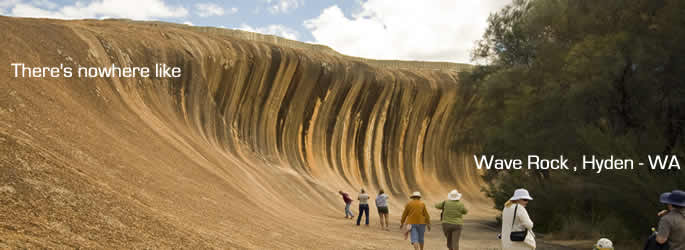
Hyden
The
rich
fertile
land
in
the
region
led
to
the
commencement
of
wheat
production
in
1927.
Cunderdin
Cunderdin
was
first
settled
with
the
arrival
of
the
railway
in
1894.
In
1901,
the
Goldfields
Water
Scheme
reached
the
town
bringing
with
it
an
increase
in
population.
Tammin
Tammin
derives
its
name
from
a
small
marsupial,
the
Tamma
and
was
the
first
wheatbelt
town
to
have
a
concrete
grain
silo
installed.
Kellerberrin
The
area
was
first
explored
by
Ensign
Dale
in
1830.
The
Kellerberrin
townsite
was
settled
in
the
early
1890's,
the
railway
was
laid
in
1893/94
followed
by
the
Goldfields
Water
Scheme
in
1901.
Merredin
In
1892,
when
goldfields
were
discovered
in
Coolgardie,
a
stream
of
diggers
and
prospectors
took
the
track
from
Perth
to
the
fields.
The
procession
of
laden
men
and
animal-drawn
wagons
moved
on
from
one
waterhole
to
the
next.
One
such
waterhole
was
Merredin
Peak.
In 1893
the
railway
to
the
Goldfields
reached
Merredin
and
it
passed
through
the
valley
in
which
the
present
town
now
lies,
about
3km
south
of
Merredin
Peak.
Westonia
Westonia
district
owes
its
origin
to
gold
mining.
By
1915
two
mines
were
in
operation
and
in
1917,
Westonia
had
a
population
in
excess
of
2,000.
This
number
quickly
diminished
when
mining
operations
ceased
in
1919.
The
mine
was
reopened
in
1935
and
continued
operation until
1948
when
it
was
once
again
closed.
Southern
Cross
The
1887
discovery
of
gold
in
the
Yilgarn
District
is
attributed
to
a
man
named
Glass,
who
found
gold
while
cleaning
out
a
granite
bottomed
soak
in
the
area.
Wongan
Hills
Until
the
turn
of
the
century,
the
only
white
men
to
visit
the
area
were
the
Sandalwood
cutters
and
monks
shepherding
sheep
from
New
Norcia.
The
first
settlers
arrived
in
1905.
Wongan
comes
from
the
Aboriginal
word
for
'whispering'.
Goomalling
The
district
was
first
explored
in
1854
by
Assistant
Surveyor
Austin.
The
name
was
derived
from
the
Koomal
Possum
which
widely
inhabited
the
area
when
the
district
was
first
established
in
1902.
Dowerin
Dowerin
is
taken
from
the
Aboriginal
word
"Daren",
given
to
a
series
of
lakes
approximately
8km
from
the
town,
that
were
once
freshwater.
Wyalkatchem
In
1904
J.H.
Riches
and
J.
Lindsay
were
the
first
settlers
to
take
up
land
in
the
Wyalkatchem
area.
Wheat
was
under
crop
as
early
as
1907
and
the
townsite
of
Wyalkatchem
was
declared
in
1908.
Tranying
The
name
originated
from
the
Trayning
Well,
derived
from
the
Aboriginal
word
"During"
meaning
"snake
in
the
grass
by
the
campfire"
Nungarin
J.S.
Roe
led
an
expedition
through
the
area
in
1836.
The
town
was
a
depot
for
Australian
army
personnel
from
1944
to
1960.
Koorda
In
1836
the
Surveyor
General,
J.
S.
Roe,
led
an
expedition
to
the
east
of
the
Avon
Valley
in
search
of
pastoral
land.
One
of
his
camps
was
located
a
few
kilometres
north
of
the
present
town
of
Koorda.
Bencubbin
The
town
of
Bencubbin
began
to
develop
in
the
early
1900's
and
its
name
comes
from
the
Aboriginal
word
'Gnylbencubbing'.
Mukinbudin
The
first
pastoral
settlers
arrived
in
the
area
in
the
1870's
and
took
up
their
leases
to
run
sheep.
Wheat
fanning
began
by
1910
and
stock
was
added
after
1928,
when
reliable
water
supplies
became
available.
The
district
has
many
interesting
historical
and
natural
features
including
the
gnamma
hole
at
the
site
of
the
Wattoning
Homestead,
where
there
are
also
three
historical
graves.
Among
the
noteworthy
rock
outcrops
are
Barbalin
Rock,
Bebringbooding
Rock
and
Be-eranning
Hill.
All Photos courtesy of Tourism Western Australia
|